Photo Credit: Cameron Gillie
We’re going to do more trail improvement on Monday, June 12 to (hopefully) complete the great work done on Saturday, June 3.
What: Clear invasive brush to improve forest health, reveal the area’s natural beauty and enhance the hiking experience.
When: Monday, June 12, 9:00 AM to 2:00 PM. June 12 is a rare opportunity to use gas chainsaws (due to noise) in this patch of woods. We won’t have another opportunity until the course closes in late fall.
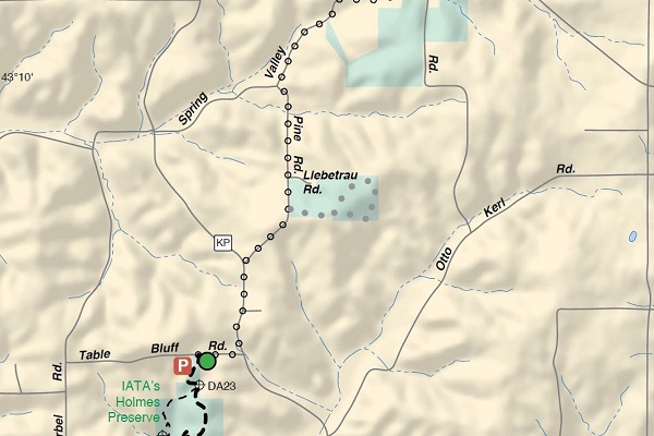
Where: University Ridge Golf Course. Enter through the main gate at 9002 County Hwy. PD, Madison. See the attached map.
PARKING:
1. Please park in the back of the parking lot near the clubhouse, then take the short walk on the Ice Age Trail to the work area.
or
2. Park at the Noer Turf Research Facility, 2502 S. Pleasant View Rd. (County M), Verona and walk the Ice Age Trail to the work area. It is a short walk.
or
3. There will be some parking on the grass, on the north side of the dirt cart path shown on the map. This is the left side as you pull in. Park with all wheels in the grass–please don’t block the path.
4. It is OK to park along the main road, IF all four wheels are in the grass.
**Monday is the day after the AmFam tournament wraps up. The course is closed to golfing. Expect lots of trucks and heavy equipment on the road and in parking areas.
What to wear/what to bring: Wear a hat, long-sleeved shirt, long pants, socks and lightweight boots. There is plenty of thorny gooseberry and multiflora rose. Leather gloves are a must. It is tick season. Wear outer clothing treated with Permethrin. Tick-borne illness is no fun! Bring plenty of water, snacks and lunch.
Courtesy: If you are going to arrive late or cannot come as planned, I understand. Please afford me and your fellow volunteers the courtesy of a phone call, text or email to me as early as possible. Thank you.
If you plan to help on June 12, please reply to this message. This is very important so I can plan for enough tools and supplies. It also allows me to communicate with you, should plans change due to weather, etc.
Questions? Call, email or text me. I hope to see you on June 12! Happy Trails
Link to details: June Trail Improvement Project map


