Join the Ice Age Trail Alliance Lodi Valley Chapter for our next Tyke Hike at the Lodi Marsh Segment. These short walks are designed for young children accompanied by an adult, with a focus on noticing things in nature. During this hike we’ll look for what’s going on in early spring.
Meet at the Twin Pines trailhead of the Lodi Marsh Segment on Lodi Springfield Road.
Wear appropriate clothing for the weather, sturdy shoes, and in case of slippery conditions, a walking stick is useful. Leashed, well behaved dogs are welcome.
For more information, call Bill @ 608-843-3926 or email at billpatti@charter.net
Featured image by: Karen Smith
Join us for a special candlelight hike at the Gibraltar Rock Segment on February 24. Hike along an illuminated path up the hillside to watch the full moon. February’s moon is called the snow moon.
Meet at the Ferry Landing Parking Lot, Hwy 113 Lodi at 7:30 p.m.
Wear appropriate clothing for the weather, sturdy shoes, and bring a light as well, and in case of slippery conditions, a walking stick is useful. Leashed, well behaved dogs are welcome.
For more information, call Bill @ 608-843-3926 or email at billpatti@charter.net
Featured image by: Rachel Roberts
Join the Ice Age Trail Alliance Lodi Valley Chapter for our next Tyke Hike. These short walks are designed for young children accompanied by an adult, with a focus on noticing things in nature. During this hike we’ll look for what’s going on in winter.
Meet at the Gibraltar Rock Segment parking lot at Gibraltar Rock Road.
Wear appropriate clothing for the weather, sturdy shoes, and in case of slippery conditions, a walking stick is useful. Leashed, well behaved dogs are welcome.
For more information, call Bill @ 608-843-3926 or email at billpatti@charter.net
Featured image by: Lisa Jones
Wolves have howled at the Moon for centuries, yet it is still there…
Join us on Thursday evening, January 25th, for a short walk (perhaps to howl?) in the light of the full moon at the Lodi Marsh Segment. The January full moon is often called the Wolf Moon or sometimes the “stay at home” moon…but come out and howl!
We will meet at the Robertson Trailhead on Lodi/Springfield Road at 7:30 pm. Watch for the yellow “Ice Age Trail Event” signs. For directions visit:https://goo.gl/maps/RE2C5
Wear appropriate clothing for the weather, sturdy shoes, and bring a light as well, and in case of slippery conditions, a walking stick is useful. Leashed, well behaved dogs are welcome.
For more information, call Bill @ 608-843-3926 or email at billpatti@charter.net
Featured image by: Cameron Gillie
THIS EVENT IS CANCELLED!!!
The Ice Age Trail Alliance – Lodi Valley Chapter invites you to join us for our next Tyke Hike! During this hike we’ll enjoy whatever winter weather we happen to have! These short walks are designed for young children accompanied by an adult, with a focus on noticing things in nature.
We hope to see you at the Tyke Hike!
Event details: Saturday, January 20th at 10:00 am
Location details: We will meet at the Robertson Trailhead on Riddle Road; Watch for the yellow Tyke Hike signs.
Event Description
Join the Ice Age Trail Alliance, Lussier Family Heritage Center and Dane County Parks at the Winter Fun Extravaganza! The event will be a great opportunity to get outside this winter. Ice Age Trail Alliance volunteers will be at the snowshoe area to help attendees with gear and questions. Alliance members will also have maps, stickers and bandanas for everyone who comes by to say hello.
Here is a list of fun things that will be going on that you can participate in.
- Sledding – A few sleds will be available at first come, first serve basis.
- Warming Shelter Fire – We will light up the fire in the warming shelter and be providing s’mores with a donation to our environmental education programs.
- Snowshoeing – Snowshoe rentals will be $5 a pair to use during the event on a first come, first serve basis.
- Permit Free Weekend for Cross County Skiing!
- Bonfire – We will have a bonfire going at the shelter and be providing s’mores and hot chocolate with a donation to our environmental education programs.
- Snow free play! Use our igloo bricks to build an igloo, make snow people and more!
This is a free event open to the public, no registration is required. This event is weather dependent, check Dane County Parks’ Facebook event page and other social media platforms for cancelations.
Location
Indian Lake County Park
8183 State Highway 19
Cross Plains, WI 53528
Get Directions
*Image credit: Lussier Family Heritage Center, Dane County Parks
Enjoy a nice wintertime hike! There is not quite enough snow to use snowshoes, but that won’t stop us from having lots of fun. Come out for a nice time!
This event is cancelled due to weather. Please check back for more group hike opportunities!
Enjoy a nice wintertime hike, and if there is enough snow (fingers-crossed) we will be using snowshoes. Come out for a nice time!
Chase a few blazes to start the New Year! Join the Marquette Co. Chapter on New Year’s Day for a First Day Hike at John Muir County Park.
Hike Details:
Follow in Muir’s footsteps and experience the prairies and meadows of his boyhood home. The 1.8-mile John Muir Segment showcases a hummocky terrain, drumlins, and features views of Ennis Lake. After the hike, warm up with some hot chocolate, provided by the Chapter. Well-behaved, leashed dogs are welcome.
What to Bring:
Dress for the weather, wear comfortable hiking boots, bring hiking poles (if you use them) and water, etc.
Location:
Meet at John Muir County Park (Montello, Wis.) at 10:55 a.m. Parking is adjacent to Trail access.
Contact Info:
Contact Jeff Frazer, Chapter Coordinator, with any questions: morgmule@yahoo.com
Featured image by: Cameron Gillie
Join the fun on Thursday, December 21, 2023 to celebrate the Winter Solstice on the Ice Age Trail!
Details
Dress for the weather. Headlamps and/or flashlights will be needed. There are no bathroom facilities available at the Springfield Hill Segment.
After the hike, enjoy FREE hot cocoa provided by the Dane County Chapter of the Ice Age Trail Alliance. All are welcome, including well-behaved and leashed dogs.
Springfield Hill Segment
This segment, a short loop that can be hiked in either direction, highlights the 198-acre Springfield Hill Natural Resource Area. This property consists of steep wooded valleys, glacial kettle ponds, and open meadow. The stunning prairie changes with the seasons and demonstrates what’s possible through extensive and ongoing restoration efforts. The Trail’s route provides outstanding views from atop Springfield Hill, one of the highest points in the area.
Photo by Joe Ulmer.
Traverse open prairie and grassland of Roznos Meadow while enjoying the views of the surrounding Baraboo Hills. Climb the East Bluff’s south face as you enter Devil’s Lake State Park, relishing fall color along the way. We’ll meet up with the park’s Upland Trail Loop and take it over to the parking lot on Hwy 113. Shuttles will return you to your vehicle.
Hike Details:
- Date & Time: Tuesday, October 24, 9:30 a.m. – noon.
- Total hike distance: 3.5 miles
- Elevation gain: 500 feet
- Starting point: Meet at Roznos Meadow parking lot (43.40561, -89.67520)
- Ending point: Hwy 113 parking lot (with shuttle back to vehicle) (43.42547, -89.68648)
- Hike leader: Debby Capener (debbycapener@gmail.com)
State Park Pass required for vehicle at starting point’s parking lot.
Photo Credit: Brent Sieling
The Hike
The Trail starts from the parking lot heading south between two agricultural fields before entering a wooded area, and then winds uphill and west before turning to the south, passing an impressive bedrock outcropping dotted with ferns. It then continues east through an agricultural field and turns southeast to a high plateau. The Trail turns east when entering another woods, and drops down a ridge, then continues south across a farm field and reenters the woods. From this point the segment climbs gradually up the west side of a sandstone ridge, eventually making its way to a fine goat prairie and trailside bench with outstanding views across a glacial outwash plain to the Sugar River watershed and the city of Belleville. The segment takes a northeast turn and crosses a high prairie plateau before entering a woods and turns southeast to reach Cty Hwy D.
Event Details
We’ll hike the Ice Age Trail south while traversing through wooded and prairie areas. From sandstone vistas we’ll see the surrounding Sugar River Valley area. This is an out and back moderate hike (from Frenchtown Rd to Hwy D) with some rolling hills and with a total distance of about 5.5 miles.
Well behaved dogs are welcome on leash.
Be aware of possible Hwy 69 construction and allow extra time to arrive as portions may be closed. May need to access Frenchtown Rd from either Hwy PB (west) or Hwy D (east).
Location
Meet at Parking lot at the intersection of Piller Rd and Frenchtown Rd.
Photo Credit: David Lonsdorf
The Hike
The Prairie Moraine section of the Verona Segment starts at the gate in the northwest corner of the parking lot, adjacent to the fenced off dog exercise area, and heads north before turning to the east. It then climbs a few switchbacks to a saddle of the terminal moraine on the St. Peter sandstone bedrock. There is a spur trail to the east to a viewing platform offering views of a ravine cut in the moraine by meltwater and of the upper Sugar River Valley in the Driftless Area to the south. The Ice Age Trail continues from the junction with the spur trail to the northwest about 0.8 miles, descending along the north-northwest side of the moraine before heading north through the woods for a short bit. The Trail then crosses Cty Hwy PB at the end of the median in the road (caution: heavy traffic), before going south to enter the Moraine Kettles portion of the Verona segment. As you head west on the segment, you will see a sign the noting the old section of roadway for the County Farm Paoli Road that was in use from 1882 to 1929. The Trail continues to the west before turning north to cut through a prairie with tall grasses and wildflowers. The next set of woods has several kettle ponds formed from ice buried when the glaciers retreated, subsequently melting to form a depression that usually fills with water. Finally there is another small prairie before reaching the Moraine Kettles parking lot and Cty Hwy M.
Event Details
Time for an evening hike on the Ice Age Trail at Prairie Moraine County Park, southeast Verona. We’ll hike through prairies and woods where you can enjoy Dane County’s most visible section of the glacial terminal moraine. Total will be 2.5-3 miles as we’ll enjoy the trail up to County M through a section we call Moraine Kettles due to some nice kettle ponds we’ll go by. We’ll also explore off the IAT in Prairie Moraine a little by going up to the observation platform for some great views of the Sugar River valley.
Location
At the gate/kiosk in the first lot as soon as you turn on Wesner Rd.
Photo Credit: MacKenzie McDermit.
The Hike
The Brooklyn Wildlife segment traverses an area featuring highly eroded glacial deposits from an earlier glacial advance more than 60,000 years ago. The segment highlights meadows, woodlands, oak savannas, and colorful prairies. The variety of habitats in the area results in great bird-watching opportunities. Herons and cranes fish in the Story Creek wetlands and plenty of turkeys resting with their young can be stirred up on sandy portions of the segment. Volunteers from the Friends of Brooklyn Wildlife Area and the Ice Age Trail Alliance’s Dane County Chapter have worked extensively on prairie restoration and removal of invasive species throughout the Brooklyn Wildlife Area. When heading north from the blue spur trail from the Hwy DD South parking lot, you will encounter a particularly impressive overlook and view from the Trail of the Story Creek wetlands and the Johnstown Moraine. Heading south of the blue spur trail will lead to a trail-side hand water pump.
Event Details
We’ll explore several miles of the Brooklyn Wildlife Area along the Ice Age Trail — maybe around 5 miles total. There’s several parking areas on that segment – we’re meeting in the larger one in the middle of the segment. Should see lots of summer prairie plants, but we’ll also be in some wooded areas that should be a bit shadier at times.
Well behaved dogs on leash are welcome.
Location
The ‘Hwy DD South’ parking lot entrance is about .8 miles south of the Dane County Hwy D intersection with Hwy DD, and just north of the Green County line.
Photo Credit: Black-eyed Susans in full bloom along the Table Bluff Segment of the Ice Age National Scenic Trail by Gary Hegeman.
The Hike
Come out for a hike on this showcase IAT property! The southern end of this segment was formerly owned and manged by the non-profit Swamplovers, before they donated the land to the IAT. The wetlands across from the parking lot are the result of meltwater from the Laurentide ice sheet pouring through a preglacial valley and depositing sand and gravel and partiality filling the valley floors, which now hold wetlands and a tributary stream of Black Earth creek, a Class I trout stream. The hike starts out with several switchbacks to climb to the top of the bluff, featuring dramatic rock outcroppings of Ordovician dolomite and views to the southwest to the Blue Mounds. There is a white-blazed loop trail in addition to the main IAT trail on the hilltop. After a prairie/oak savanna that is being restored to its native state, the IAT traverses nearly a mile of of woodlands of oak and hickory before descending to the valley floor. In the valley is a second white-blazed loop trail that offers a half mile ‘bubble’ to the west of the IAT. The trail continues across the valley to rise up the opposite hillside and into a wooded area. Enjoy the more than 20 years of prairie restoration efforts in the large restored prairie with a thriving population of rare pale purple coneflowers, plus shooting star, rattle-snake master, stiff gentian, hoary vervain, prairie smoke, cream gentian, and cream baptisia have all been identified here. Exiting the prairie and heading downhill, you will encounter the other end of the second white-blazed ‘bubble’ trail. The trail then begins climbing through another prairie/oak savanna before ending at the Table Bluff Road parking lot.
Event Details
Hike through the prairies and wooded areas near Table Bluff — out in the driftless area. Round trip is 4.8 miles with a couple moderate hills. There’s a couple of white loop trails in that area we can take to vary this hike a bit, so not a complete out and back. We’ll explore the restored prairies and oak savannas along the trail and hopefully have a great view overlooking the Black Earth Creek valley with Blue Mounds off in the distance. And of course be on the look out for the Swamplovers alligator!
We can also offer a one-way 2.5 mile option with shuttle back to the start.
Well behaved dogs on leash are OK to join us.
Location
Hikers will meet at the Swamplovers end of the trail on Scheele Rd. From HWY KP, turn onto Scheele Road, which has a right turn before entering Swamplovers. The parking lot is on the right.
Photo Credit: Black-eyed Susans in full bloom along the Table Bluff Segment of the Ice Age National Scenic Trail by Gary Hegeman.
The Hike
Come out for a short evening stroll on this Dane County Parks property that is part of the Table Bluff segment of the Ice Age Trail. The trail has some gentle, rolling hills and a looping portion of the trail goes through a section of woods. This 1.5-mile loop offers a grand view toward Blue Mounds (on a clear day).
Enjoy the more than 15 years of prairie restoration efforts. In spring, hikers will see shooting stars and other early prairie flowers; in summer, prairie flowers include an ever-changing explosion of compass plants, monarda, rudbeckia, coneflowers, coreopsis, milkweed, liatris and many more.
Event Details
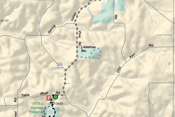
The hike is about 1.5 miles round trip from the Pine Rd parking lot.
Location
Hikers will meet at the IATA parking lot on Pine Road Liebetrau Prairie – Table Bluff Segment
Photo Credit: Brent Sieling
The Hike
Springfield Hill Segment is currently a small loop trail that can be hiked in either direction. Enjoy the extensive restoration work done if you start your hike to left, with overgrown honeysuckle, buckthorn, and walnut trees have been removed to restore native prairie. The trail ascend to the crest of a hill with a south-facing slope offering dramatic views to the south and west. Summer wildflowers include monarda, spiderwart, and coreopsuis. After descending off the ridge, the segment continues through woods before entering an oak savanna, and then crosses a wooden boardwalk before passing the remains of Frederic Hahn’s log outbuilding dating to the late 19th century. The segment continues along a goat-prairie hillside and passes an old cattle road underpass before returning to the parking lot.
Event Details
Springfield Hill is Dane County Park location hosting a 1.6 mile loop segment of the Ice Age Trail being restored to oak savanna. Mostly full moon will rise just after 7, so should have a nice view during the hike.
Dogs on leash can join. No facilities onsite.
Location
The parking lot entrance is on Ballweg Road, about 1000 ft north of of the intersection with Hightway 12.
Celebrate summer with the Superior Lobe Chapter of the Ice Age Trail Alliance on a Community Hike for All Ages and Abilities!
Meet others from your community (maybe even a new hiking buddy) and see how you feel after spending a bit of time on the Ice Age Trail.
Details:
June 24, 2023 @ 10:00 a.m.
Enjoy an up to 2-miles guided hike on a flat portion of the Tuscobia State Trail. Before the hike, enjoy a Nordic Walking demonstration and stay for a grill out with hot dogs afterwards.
An all-terrain wheelchair is available! Please email Clare (cjgv@chibardun.net) in advance to reserve.
Location:
Tuscobia State Trail
Meet at Brill Millers Baseball Parking Lot
2347 27 1/2 Ave. Rice Lake, WI 54868
Contact:
Email Clare (cjgv@chibardun.net) with any questions.
Event co-sponsored by Superior Lobe Chapter and Barron County Special Olympics
Photo Credit: Emily Meier
The Hike
Event Details
Now is the season and early morning is the time to see and hear migrating and newly-arrived birds of the woodlands, savanna and prairie habitats along the loop in the highlands above Cross Plains. Binoculars and field guide recommended. Your leader will help to identify avian friends by both sight and sound.
Location
See map below.


