Photo Credit: Nick Lane
Event Details
Have you ever been out at dusk to listen for owls? Now is your chance! Join Dane County Parks education staff and the Ice Age Trail Alliance to explore Indian Lake County Park and look and listen for this incredible raptor. Please ensure that you are dressed appropriately for the weather as we will be outside during the entirety of the program.
Program includes an estimated 2-mile guided walk through the park, which goes along the Ice Age Trail, and will end with a fire, roasting s’mores, and continuing our search for owls.
Please note: there is no guarantee to see or hear an owl during the walk.
The Hike
We will meet at Indian Lake County Park shelter #1 before heading onto the Ice Age Trail. This walk will be an estimated 2 miles and will go at a group set pace.
Location
The entrance for Indian Lake County Park is near the intersection of State Highway 19 and Matz Rd. Follow the entrance road south to the parking area.
Registration
Please register in advance though Dane County Parks. $5 per person. Kids under 5 are free and do not need to register.

Photo Credit: Rachel Roberts
The Hike
The hike starts at the Ice Age Junction parking lot then goes north on the multi-use trail bridge over McKee Rd before veering off over a grassy moraine, with two interpretive signs about the presence of glaciers in the area. It then crosses the multi-use path again and parallels it heading north through a area of native grasses and wildflowers that is part of a restoration project begun by Veridian Homes. This prairie gives way to a small aspen and oak grove heading north along the west side of a large drainage basin. Once reaching and crossing Raymond Road, the trail once again leaves the multi-use trail and heads west through a small woods and then into a field with tall grasses and wildflowers before rejoining the multi-use path for 300 feet to use an underpass below Pleasant View Rd. The trail finally leaves the multi-use path for the last time before crossing a covered bridge to reach the University’s Noer Turfgrass Research Center driveway and continuing up the drive for 50 ft before turning to the southwest. It then continues through a grassy area, a small patch of woods and then past an agricultural field to reach the UW’s Golf Course practice area. The trail then climbs a moraine with expansive views to the east and south. Continuing on, the trail crosses a golf cart path and through a small wooded area, before briefly following a golf cart path and then passing between two tee boxes. The trail bends north through a grassland area located west of a fairway to reach the golf course’s lower parking area and the clubhouse to the right. Hikers are welcome to use the clubhouse, which features water, restrooms and a restaurant. From the clubhouse area the trail goes north and then west, hiking through wooded areas between holes of the University Ridge golf course and crossing a golf cart path before more wooded areas to reach Woods Road.
Event Details
Join hike leader, Kathy, on a 6 mile round-trip (out and back) hike on the Ice Age Trail from Verona to University Ridge Golf Course clubhouse. For those who wish a shorter 3-mile hike ending at University Ridge Golf Course, please arrive at the starting location at 9:15 am to arrange a car shuttle. The hike starts at Ice Age Trail Junction parking lot located at Hwy PD/McKee Rd and High Point Rd. The hike will traverse north and west to University Ridge Golf Course and return back to the Hwy PD parking lot. This surprisingly remote feeling segment passes unobtrusively through a scenic golf course and residential neighborhoods.
Tick and mosquito season is upon us. It is recommended that you wear long pants and long sleeves. Please bring bug repellent (or wear clothes soaked in Permethrin). Also bring water and a snack.
Location
The parking lot entrance is on the south side of the intersection of HWY PD and High Point Rd. Continue past the two metal sheds to the parking area.
Photo by Vicki Christianson
The Hike:
Please join us as we hike the western portion of the IAT’s Blue Spring Lake Segment. This up & down segment features panoramic views from the top of Bald Bluff, and the Stone Elephant, a massive granite erratic.
Details:
We will shuttle cars to the Bald Bluff Nature Trail parking lot where we will begin our hike. We will hike north and east ~3 ½ miles to the Horseriders Campground. Dogs are welcome but must be leashed and cleaned up after. Dress for the weather and wear comfortable walking shoes. Hiking poles will be helpful. Bring water for the hike.
Note: We do not cancel hikes ahead of time due to weather predictions. If that morning we have a deluge, or lightning, Mark will send out an email canceling…if you are not sure, stay home.
Location:
We will meet at the Horseriders Campground, leave some cars there and drive to the Bald Bluff Nature Trail parking lot.
Contact Information:
Dick Haas and Jeff Romagna help Mark Miner organize these hikes. Email comments or questions to Mark, your hike leader, and he will answer them for you.
Photo by Diane Clauer-Hauser
This hike has been CANCELLED!
The Hike:
Please join us as we hike the Milwaukee River Segment in Fond du Lac County. Paralleling the Milwaukee River, this Ice Age Trail segment traverses the densely wooded hillsides of the Northern Kettle Moraine and follows an irregular hummocky sand and gravel ridge for most of its length.
Details:
We will shuttle cars to the New Fane Trailhead where we will begin our hike. We will hike approximately four miles from there to the Mauthe Lake Recreation Area. Additional hiking can be added at Mauthe Lake. Bring a lunch if you wish to picnic after the hike at Mauthe Lake. Dogs are welcome but must be leashed and cleaned up after. Dress for the weather and wear comfortable walking shoes. Bring water for the hike.
Note: We do not cancel hikes ahead of time due to weather predictions. If that morning we have a deluge, or lightning, Mark will send out an email canceling… if you are not sure, stay home.
Location:
We will meet at the Mauthe Lake Recreation Area.
Contact Information:
Dick Haas and Jeff Romagna help Mark Miner organize these hikes. Email comments or questions to Mark, your hike leader, and he will answer them for you.
Photo Credit: Nick Lane
The Hike
Evening hike on a newer portion of the Ice Age Trail. The Trail now extends north from Indian Lake County Park on north side of Hwy 19 in the Halfway Prairie Wildlife Area.
Event Details
We’ll start in Indian Lake Park by the shelter, but then head north along the Trail, cross Hwy 19, check out the Matz farmstead ruins (built in 1907 and burned in 1948), and hike to where the segment ends. We’ll then loop around on some of the other trails on the property to return. About 3.5 miles total.
Tick and mosquito season is upon us. It is recommended that you wear long pants and long sleeves. Please bring bug repellent (or wear clothes soaked in Permethrin). Also bring water and a snack.
Location
The entrance for Indian Lake County Park is near the intersection of State Highway 19 and Matz Rd. Follow the entrance road south to the parking area.
Photo Credit: Brent Sieling
The Hike
Springfield Hill Segment is currently a small loop trail that can be hiked in either direction. Enjoy the extensive restoration work done if you start your hike to left, with overgrown honeysuckle, buckthorn, and walnut trees have been removed to restore native prairie. The trail ascend to the crest of a hill with a south-facing slope offering dramatic views to the south and west. Summer wildflowers include monarda, spiderwart, and coreopsuis. After descending off the ridge, the segment continues through woods before entering an oak savanna, and then crosses a wooden boardwalk before passing the remains of Frederic Hahn’s log outbuilding dating to the late 19th century. The segment continues along a goat-prairie hillside and passes an old cattle road underpass before returning to the parking lot.
Event Details
Springfield Hill is Dane County Park location hosting a 1.6 mile loop segment of the Ice Age Trail being restored to oak savanna. Mostly full moon will rise just after 7, so should have a nice view during the hike.
Dogs on leash can join. No facilities onsite.
Location
The parking lot entrance is on Ballweg Road, about 1000 ft north of of the intersection with Hightway 12.
Photo Credit: David Lonsdorf
The Hike
The hike starts at the Ice Age Junction parking lot and joins the Ice Age Trail to go south through a ~200-acre restored prairie. This is named the Ice Age Trail Junction Area and is managed by the Dane County Parks Department and provides a visual and physical separation between the cities of Verona and Madison. The Ice Age Trail shares this area with a paved multi-use trail. The trail continues south with some outstanding views through a wooded area and follows to the left at a fork. The segment heads further south and reaches a short spur trail near a maintenance shed that leads west to picnic tables and a kiosk display explaining the prairie restoration program and Upper Sugar River Valley. Several mowed paths will intersect the Trail near the Reddan Soccer Park; continue to follow the Trail straight toward Cross County Road. The Trail turns west and crosses Cross County Road at a marked pedestrian crossing. The Trail enters Badger Prairie County Park and continues southward across a ridge. Hikers will pass through a Dispersed Camping Area and shortly reach the turn-around point at the park’s main shelter.
Event Details
Join hike leader, Rich, on a 4-mile round-trip (out and back) evening hike on the Ice Age Trail on the Verona Segment. The hike starts at Ice Age Trail Junction parking lot located at Hwy PD/McKee Rd and High Point Rd. This is a family-friendly out and back casual hike with some rolling hills. The hike will traverse south to the Badger Prairie County Park main shelter and return back to the Hwy PD parking lot. The segment passes through a combination of prairie and wooded areas.
Tick and mosquito season is upon us. It is recommended that you wear long pants and long sleeves. Please bring bug repellent (or wear clothes soaked in Permethrin). Also bring water and a snack. We should be done by sunset, but just in case, you might want to bring a headlamp or flashlight.
Location
We’ll meet at the parking lot with its entrance on the south side of the intersection of HWY PD and High Point Rd. The intersection has a stoplight and is about 1 mile east of Hwy M. You can find it on Google Maps by searching for “Ice Age Trail Junction Area.” Continue past the two metal sheds to the parking area.
Trail Friends,
Tired of being cooped up all winter? Want a tune-up before the June 4th Mammoth Fun Run & Walk? Or maybe you just want an excuse to get ice cream at the ferry landings?
Mark your calendar for our 13th annual saunter starting at Devils Lake State Park and ending at Gibraltar Rock, a distance of about 11 miles, through some of the most beautiful and unique terrain in southern Wisconsin.
We will start at the Devils Lake State Park Roznos Meadow parking lot on Hwy 113 (https://goo.gl/maps/xk7FxrQEa4K2) at 9:00 am on Saturday, May 21st. A bus will be waiting at the Gibraltar Rock west parking area to shuttle hikers back to Roznos Meadow.
Please dress appropriately for hiking and the weather. Bring lots of water, snacks, and a lunch. For more information before the hike, call Bill at 608-843-3926 or email at billpatti@charter.net.
For information the day of the hike, call Judy at 608-576-2190 or Jim at 608-444-4611
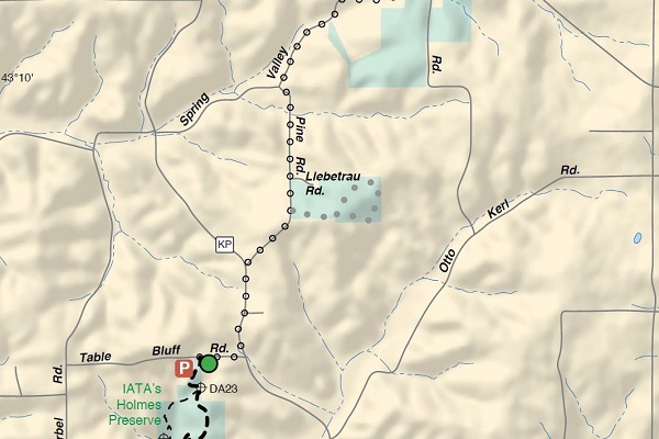
Photo Credit: Black-eyed Susans in full bloom along the Table Bluff Segment of the Ice Age National Scenic Trail by Gary Hegeman.
The Hike
Come out for a short evening stroll on this Dane County Parks property that is part of the Table Bluff segment of the Ice Age Trail. The trail has some gentle, rolling hills and a looping portion of the trail goes through a section of woods. This 1.5-mile loop offers a grand view toward Blue Mounds (on a clear day).
Enjoy the more than 15 years of prairie restoration efforts. In spring, hikers will see shooting stars and other early prairie flowers; in summer, prairie flowers include an ever-changing explosion of compass plants, monarda, rudbeckia, coneflowers, coreopsis, milkweed, liatris and many more.
Event Details
The hike is about 1.5 miles round trip from the Pine Rd parking lot.
Location
Hikers will meet at the IATA parking lot on Pine Road Liebetrau Prairie – Table Bluff Segment
Photo by Peter Dargatz
The Hike:
We will walk the trails in Riverside Park and then return to the lakefront (about 2 1⁄2 miles) via the Milwaukee River Line of the Oak Leaf Trail. Once at the Lakefront people can choose to walk further along the lake shore if they wish.
Details:
Dogs are welcome but must be leashed and cleaned up after. Dress for the weather and wear comfortable walking shoes (much of this hike is paved). Bring water for the hike.
Note: We do not cancel hikes ahead of time due to weather predictions. If that morning we have a deluge, or lightning, Mark will send out an email canceling… if you are not sure, stay home.
Location:
Meet at Colectivo Lakefront (the historic Milwaukee River Flushing Station). You can park along Lakeshore Drive or in the McKinley Park lot across the street from Colectivo. We will leave some cars on the lakefront and shuttle to the Urban Ecology Center at Riverside Park to walk the trails in Riverside Park.
Contact Information:
Dick Haas and Jeff Romagna help Mark Miner organize these hikes. Email comments or questions to Mark, your hike leader, and he will answer them for you.
Join us for our first Mid-Week Hike of the year!
The Hike:
We will walk south on the Fox River Trail to Bethesda Park and loop back to Waukesha’s Schuetze Recreation Center.
Details:
Walk at your own pace for whatever distance you wish (1.7 to 4 miles) on the paved trail. Dogs are welcome but must be leashed and cleaned up after. Dress for the weather and wear sturdy shoes/boots. Bring water for the hike.
Note: We do not cancel hikes ahead of time due to weather predictions. If that morning we have a deluge, or lightning, Mark will send out an email canceling… if you are not sure, stay home.
Location:
This hike will start out at Waukesha’s Schuetze Recreation Center located at 1120 Baxter St, Waukesha, WI 53186
Contact Information:
Dick Haas and Jeff Romagna help Mark Miner organize these hikes. Email comments or questions to Mark, your hike leader, and he will answer them for you.
Photo by Christopher White
The Tyke Hike:
Join us on a family-friendly hike to explore Wisconsin’s own Ice Age National Scenic Trail on a paved trek along the Bark River! We will explore a tyke-sized portion of Waukesha County’s Hartland Segment. Families with children of all ages are encouraged to attend!
Tyke Hikes give kids the opportunity to explore, discover and participate in natural play. Specifically, they can cover up to 1.5 miles over the course of 1-2 hours. They last approximately 1-2 hours and can cover up to 1.5 miles. Tyke Hikes are led by Peter Dargatz, a forest kindergarten teacher and Ice Age Trail volunteer.
Tyke Hike Details:
This hike’s picture book is A Fall Ball For All by Jamie Swenson. We will start our hike at the beginning of the Hartland Segment trailhead. After reading this book, we will hike for approximately 30 minutes at a child-led pace and then return. There will be occasional stops for play and exploration – stops at the playground are likely! Hikers should dress appropriately for the weather and wear comfortable footwear. Bring water.
Location:
The yellow Tyke Hike Signs will guide you to the meeting point at Hartland’s Centennial Park parking lot.
Contact Information:
Questions? Peter will answer them.
Get lost in the right direction with us!
The Hike:
Scuppernong Trails include three color-coded loop trails ranging from just over 2 miles to 5 miles. The Scuppernong area provides convenient parking, water, and a vault toilet. The trails head through rolling hills of oak forests and pine plantations. After going in and out of several kettles we will eventually end up at a beautiful overlook.
Details:
We will hike the Ice Age Trail north to where it connects to the orange loop trail. At this point you will have an option to take one of several trails back to the parking area. Dress for the weather and wear sturdy shoes/boots. Layers are helpful this time of year! Bring water for the hike.
Location:
This hike will start out at the Scuppernong Trails Parking Lot located on the north side of Hwy ZZ in the Southern Kettle Moraine State Forest. A state park vehicle sticker is required.
Contact Information:
These hikes are organized by Mark Miner with help from Dick Haas and Jeff Romagna. Email comments or questions to Mark, your hike leader, and he will answer them for you.
Details:
Meet at the Ice Age Trail Parking Lot on Kilbourne Rd. (formerly Funk Rd) east of North Lake, WI. We will then hike the Monches Segment north to where we pick up the connector trail to the Oconomowoc River Conservancy Park. We will then hike the Conservancy Park and return to the parking area on Kilbourne Road. The hike will be between 3 and 4 miles long. Dress for the weather and wear sturdy shoes/boots. Layers are helpful this time of year! Bring water for the hike.
Location:
This hike will start out at the Ice Age Trail Parking Lot on Kilbourne Rd. between Hartland and North Lake.
Contact Information:
Questions? Mark Miner, your hike leader, will answer them for you.
The Hike:
Join us on a Tyke Hike to explore Wisconsin’s own Ice Age National Scenic Trail! We will explore a tyke-sized portion of the Waterville Segment in the Kettle Moraine State Forest. Families with children of all ages should attend!
These hikes give kids the opportunity to explore, discover and participate in natural play. Most hikes include a picture book story and educational materials as well as certificates for children. In addition, service opportunities may be included. They last approximately 1-2 hours and can cover up to 1.5 miles. Tyke Hikes are led by Peter Dargatz, a forest kindergarten teacher and Ice Age Trail volunteer.
Hike Details:
We will hike for approximately 45 minutes and then return. There will be occasional stops for play and exploration along the way. Hikers should dress appropriately for the weather and wear comfortable shoes/hiking boots. Most importantly, bring water.
Location Details:
This hike will start out at the UW-Waukesha Fieldstation, W349 S1480 Waterville Rd, Oconomowoc, WI 53066.
Contact Information:
Questions? Peter will answer them for you.
“Get lost in the right direction” with us!

The Plover River Segment of the Ice Age Trail. (Photo by Cameron Gillie)
National Trails Day is Saturday, June 2nd, 2018 and there is plenty to celebrate along the Ice Age National Scenic Trail.
Hikes That Go the Distance:
Explore new territory.
Waushara County, All Waushara County Segments: “Walk the Waush” Challenge
Beginning June 1 through August 19th, challenge yourself, family, friends, and co-workers to lace up their walking shoes and walk as many miles as you can in 80 days and explore Waushara County’s beautiful parks and trails. (Bonus: become eligible for awards and prizes!) (Waushara County Chapter) Continue reading →
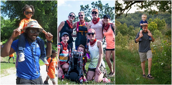
Bring your tribe hiking on the Ice Age National Scenic Trail. Photos by: Luke Kloberdanz, James Mills, Cameron Gillie
As the snow melts, trees bud out, and wildflowers begin adding a glimmer of color to the Trail, chapter-led hikes begin populating the Ice Age Trail Alliance calendar in earnest.
Continue reading →

A weekend backpacker pauses to catch his breath and take in the views along the IAT. Photo by Cameron Gillie.
Deepen your backpacking know-how with plenty of advice from backpacking experts. If you’re carefully considering a thru-hike on the Ice Age Trail as your next big adventure, or if you’re dreaming and scheming about how to section-hike the Trail in weekend jaunts, then these sessions are for you!
Join us on Saturday, April 14th at the Blue Harbor Resort in beautiful Sheboygan!
10:00 a.m. – 11:00 a.m. Trip Planning, Logistics, and Navigation.
Do you wonder how, exactly, to start planning your thousand-mile journey? If you feel a little confused, you’re not alone. The good news is there is a wealth of resources and IATA staff is eager to demystify them. You’ll learn the ins and outs of the interactive map including Trail conditions, as well as, the helpful details embedded in the Mammoth Tracks app. You’ll get the inside scoop about how to connect with chapter leaders; how to use the Thousand-Miler spreadsheet; the nitty-gritty of resupply, shuttles, and trail angels; and how to use social media to network with other hikers. Continue reading →

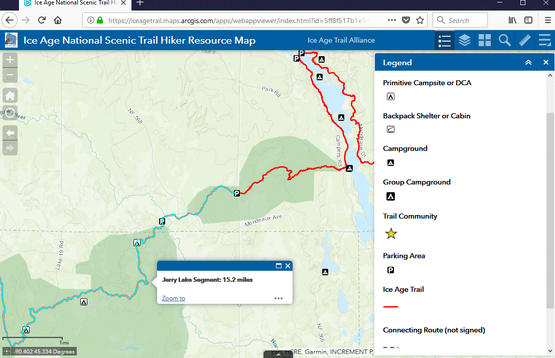
Clicking on a feature in the map will bring up more information, such as the name and length of an IAT segment.
The NEW interactive Hiker Resource Map shows all official Ice Age National Scenic Trail segments and (unsigned) connecting routes, and additional features such as camping, parking, water, ColdCache sites, and Ice Age Trail Communities. The map works on computers and mobile devices.
We like how intuitive it is. Hover over an icon to gain more information. Click on the options offered on the toolbar (see above example) to expand the information available. Continue reading →

Be Fanciful. Be a Force of Nature. Be a Nature Princess…at any age! Make a crown, dust off your boots, and come explore the wild kingdom on the Dunes Segment of the Ice Age National Scenic Trail. Photo by Woodland Dunes Nature Center staff.
Be Adventurous. Do Princesses climb trees and get dirty? Absolutely. This program, inspired by the children’s book, “Do Princesses Wear Hiking Boots?”, is designed to be a royally good time, packed with opportunities to get out and get messy. Continue reading →


")
